When the Met Office dropped an amber warning for snow across north-east England on Wednesday night, few expected it would turn into a full-blown winter siege — but by Thursday morning, roads in the North York Moors were buried under snow falling faster than plows could clear them. Meteorologist Jo Wheeler, speaking on TalkTV’s Mark Dolan Show, warned viewers: "As much as 25cm of snow could settle on high ground." And it did. By midday Thursday, drifts in the moors reached waist height in places, stranding hikers, closing trails, and turning rural lanes into impassable ice rinks.
What Happened on the Ground
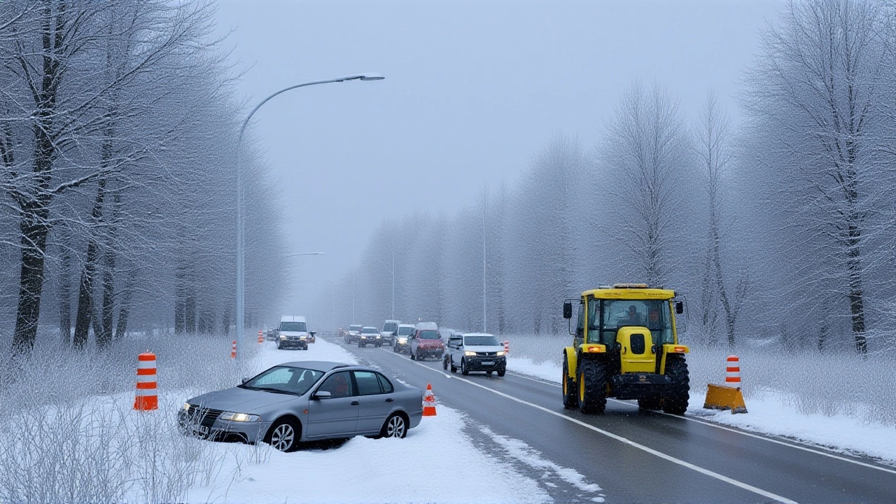
Wednesday, November 20, 2025, started as a typical late-autumn day in North Yorkshire. By 4 p.m., the sky turned slate gray. Snow began falling in earnest around 6 p.m. near Pickering and Whitby, and by midnight, the A169 — a vital link between the two towns — was shut after multiple vehicles skidded off the road. Local council crews worked through the night, but the snow came down at a rate of 3cm per hour in the higher elevations. "It was snowing on the roads as quickly as they could clear them," Wheeler told Dolan. "You’d clear a stretch, and by the time you got back to it, it was gone again." The North York Moors National Park, a 554-square-mile protected area, became a ghost town. Visitor centers closed. The North Yorkshire Police issued a plea: "Stay off the hills. This isn’t a scenic walk anymore — it’s a survival situation."The Bigger Picture: A Cold Front That Won’t Quit
According to WION’s Climate Tracker report, this wasn’t just a local blip. The storm was part of a larger Atlantic low-pressure system that had swept across Europe, bringing early winter to the UK, Germany, and parts of France. Temperatures plunged to -5°C in the moors, with wind chill making it feel like -12°C. "This is the first major arctic blast of the season," the WION anchor noted. "And it’s not leaving anytime soon." The Met Office’s amber warning — the second-highest alert level — remained active until 9 p.m. GMT on Thursday, November 21. But the real concern is what comes next. Experts say the cold front is locked in place, with models suggesting a brief warmup early next week might only bring a few days of thaw before frost and snow return. "We’re looking at wintry conditions stretching into early December," the WION report warned. That’s unusual. Most of northern England doesn’t see sustained snow this early — let alone multiple rounds.Who’s Affected — And How
It’s not just travelers. Farmers in the region reported livestock trapped in fields. One sheep farmer near Ruswarp said he had to helicopter in hay after snow blocked access roads. Power cuts hit over 12,000 homes in North Yorkshire and southern Scotland as ice weighed down overhead lines. Emergency services were stretched thin: Yorkshire Ambulance Service reported a 40% spike in calls related to falls and hypothermia. Even recreational activities took a hit. The annual North York Moors Winter Trail Run, scheduled for Saturday, was canceled — the first time in 14 years. "People come from all over for this," said organizer Sarah Kettlewell. "But when the ground’s frozen solid and visibility’s under 10 meters? No amount of enthusiasm makes that safe."
What’s Next: A Winter That Might Not End
The Met Office has already signaled that another low-pressure system is forming over the North Atlantic, with potential to deliver more snow by December 3. Climate scientists point to a pattern: the polar vortex is weakening, allowing colder air to spill south more frequently. "We’re not saying this is climate change — yet," said Dr. Elena Ruiz, a climatologist at the University of Leeds. "But what we’re seeing is more volatile transitions. Winter isn’t arriving on schedule. It’s crashing the door down." Meanwhile, local councils are preparing for a long haul. North Yorkshire Council has activated its emergency snow response plan, deploying 87 salt spreaders and calling in reserve staff. "We’ve got the gear," said council lead Mark Hargreaves. "We just hope we’ve got the patience."Ice, Not Just Snow
While the moors got the snow, the east coast got the ice. As clouds cleared over Lincolnshire and East Yorkshire on Thursday morning, temperatures dropped rapidly. Wheeler warned: "Very big risk of ice as the cloud clears away." That meant black ice on bridges, overpasses, and rural roads — invisible, deadly, and widespread. By noon, the National Highways agency had closed 14 stretches of road in the region. One driver in Scarborough described it as "like driving on glass."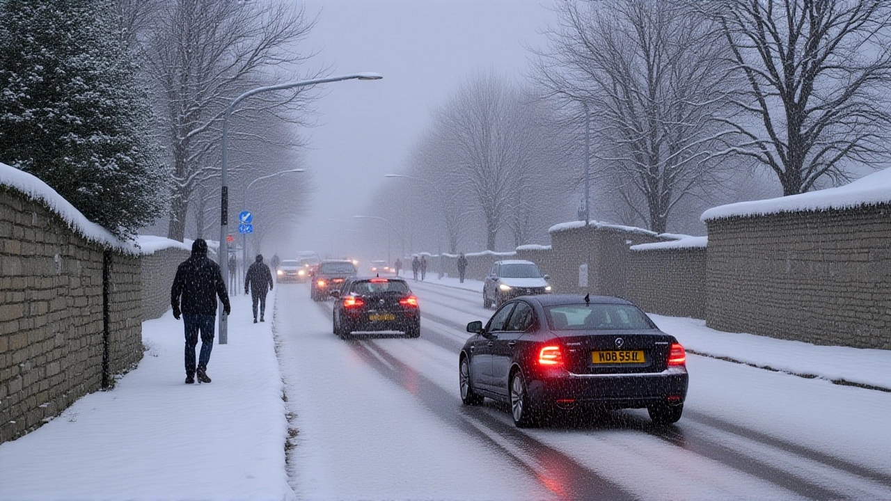
Frequently Asked Questions
Frequently Asked Questions
How does this affect local tourism and outdoor activities?
The North York Moors National Park saw a 90% drop in visitors this week, with over 20 events canceled, including the annual winter trail run. Local businesses — from cafés to guided tour operators — are losing an estimated £2.3 million in seasonal revenue. Hiking trails remain closed until at least December 5, and park rangers are advising against any non-essential travel into high ground areas.
Why is the Met Office’s amber warning so serious?
An amber warning means "be prepared" for severe weather that could cause significant disruption — including travel chaos, power outages, and danger to life. This is the second-highest level, just below red. In this case, 25cm of snow on high ground, combined with ice on lower roads and wind gusts over 40mph, created blizzard conditions. The last amber snow warning in this region was in December 2018, which led to 72 hours of transport paralysis.
What makes this winter different from previous years?
This isn’t just colder — it’s more volatile. The jet stream has weakened, allowing Arctic air to plunge south more easily. While average November temperatures in the moors hover around 3°C, this year they’ve been 7°C below normal. Climate models show this pattern — intense cold snaps followed by brief thaws — is becoming more frequent, even if overall winters aren’t necessarily longer.
Are power cuts likely to continue?
Yes. Ice accumulation on overhead lines remains a major threat, especially in rural areas like Ryedale and Hambleton. National Grid has deployed 300 engineers to the region, but with more snow forecast for early December, further outages are expected. Residents in 17 villages have been advised to prepare for up to 72 hours without power.
Is this part of a larger European weather trend?
Absolutely. WION reported similar snowfalls in the Black Forest and the Ardennes, with Germany’s DWD agency issuing its own amber warnings. France’s northern regions saw record early snowfall. The same Atlantic low-pressure system is responsible — and it’s moving slowly, meaning these conditions will linger across the continent through late November and into December.
What should people do if they’re caught in these conditions?
Stay indoors if possible. If you must drive, carry a winter emergency kit: blankets, water, non-perishable food, a shovel, and tire chains. Never attempt to walk through deep snow or icy hills — hypothermia can set in within 20 minutes. Check on elderly neighbors. And always listen to local authorities — the Met Office updates are precise, and ignoring them has cost lives before.